Price - Single rover unit only: NZ$3,880 plus P&P
Price - RTK set: NZ$7,880 plus P&P - including Base unit, Rover unit, tripod, 2m pole, smartphone (preloaded with software)
The unit can deliver centimeter-accurate coordinates over multiple wireless or wired channels making it a universal tool for all kinds of precision demanding applications.
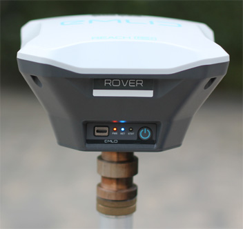
Single Rover Unit
Base Station
Use this unit to set up your own base station. Stream corrections over the network via NTRIP/TCP or LoRa radio. Record base logs for post processing.
Correction format: RTCM3
Log format: RINEX
Point Collection
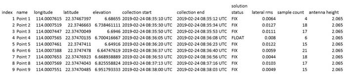
With this unit you can create survey projects to manage data collection. When working in the field each point is assigned a custom name and offset. Results can be downloaded from the project list.
Exporting formats: CSV, DXF, GeoJSON and ESRI Shapefile
Point Stakeout
Point Stakeout feature available in the App allows you to import a list of points and follow the app's guidance to reach the exact spot.
Importing Formats:- DXF, GeoJSON and ESRI Shapefile.
Rugged casing
Tough polycarbonate shall is specially crafted to protect the unit from falling and everyday wear and tear.
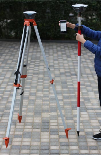
RTK Set
IP67 Certified
Sealed and enclosed makes the unit water and dustproof allowing it to work I any weather.
-20 to +65o C
Industrial Grade components ensure smooth operation no matter what the season is.
Multi-system support:- GPS, GLONASS, Beidou, Galileo, QZSS, SBAB
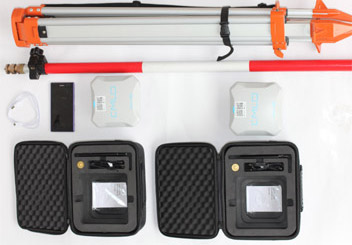
RTK Set (2 receivers, 1 tripod, 1 pole, 1 Smartphone)
Dual-feed Antenna with Tight phase centre variation
Long Range Radio:-LoRa 868/915MHz for reliable connection on distances up to 8km
30 Hours battery :- LiFePO4 battery, USB charging, external 6-40V input
8GB of storage:- Built-in memory for logs.
Sleek and intuitive software that turns any smartphone into an advanced field controller.
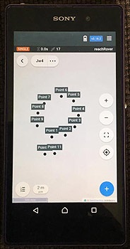
Screenshot of App
Helps with setup
Easily configure correction input, solution output, update rate and satellite systems in use. Manage Wi-Fi and Bluetooth connections.
Status monitoring
App shows current satellite strength, constellation visibility forecast, your location on a map and much more.
Surveying tools
Built in tools for data collection. Record Geolocations with specified accuracy. Import and export in industry standard formats.
Log Management
Logs are automatically recorded by internal memory. View a list of the logs and download them using the App.
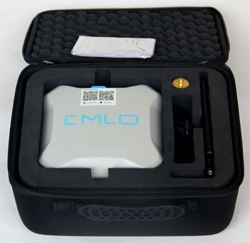
Receiver in foam packaging
Mechanical
Ingress protection:- IP67 (water and dustproof)
Size:- 145 x 145 x 85mm
Weight:- 690g
Temperature range:- -20 to +60oC
Electrical
Battery life:- 30 hours
Charging point:- Micro USB
Certifications:- FCC, CE
External Power input:- 6-40V
GNSS
Signals:- GPS/QZSS L1, SBAS, GLONASS G1, BeiDou B1, Galileo E1, SBAS
Update rate:- 14Hz GPS / 5 Hz GNSS
Tracking Channels:- 72
IMU:- 9DOF
Connectivity
Interfaces:- USB, RS232, PPS Event
Radio:- LoRa862-1020MHz
Wi-Fi:- 802.11a/b/g/n
Bluetooth:- 4.0/2.1 EDR
Positioning
Static Horizontal:- 5mm + 1ppm
Static Vertical:- 10mm + 2ppm
Kinematic horizontal:- 7mm + 1ppm
Kinematic vertical:- 14mm +2ppm
Data
Internal Storage:- 8GB
Correction Input:- RTCM2, RTCM3
Solution Output:- NMEA, ERB plain text
Logs:- RINEX2.X, RINEX3.X